Walking route 08 : Sprang-Capelle - Udenhout | The Canadian liberation route
Walk through the Loon and Drunen Dunes and pass three unique liberation locations.
Starting point: from your location
Show all 4 photos
The eighth stage (28 km) is one of the longest stages of the Canadian liberators trail. You walk from Sprang-Capelle, crossing the Loon and Drunen Dunes to Udenhout. En route you pass three locations that will tell you more about the Canadian liberators: the temporary Canadian cemetery at the Waalwijk station, the early Christmas celebrations with the inhabitants of Elshout and the Canadian military among the nuns in Brabant.
The Canadian liberation route in North Brabant runs from Woensdrecht to Oss – a total of 271 km divided into 11 stages. In 1944-1945, the Canadian military played a major role in the liberation of the Netherlands. With this walking tour you follow in their footsteps, beginning in Zeeland and going right across the Netherlands to Groningen. En route you will hear familiar and obscure tales.
Route map
You can view this route page on your telephone or download the GPX file. If you prefer to go on the walk using a paper map, you can order one in our webshop.
B…
The eighth stage (28 km) is one of the longest stages of the Canadian liberators trail. You walk from Sprang-Capelle, crossing the Loon and Drunen Dunes to Udenhout. En route you pass three locations that will tell you more about the Canadian liberators: the temporary Canadian cemetery at the Waalwijk station, the early Christmas celebrations with the inhabitants of Elshout and the Canadian military among the nuns in Brabant.
The Canadian liberation route in North Brabant runs from Woensdrecht to Oss – a total of 271 km divided into 11 stages. In 1944-1945, the Canadian military played a major role in the liberation of the Netherlands. With this walking tour you follow in their footsteps, beginning in Zeeland and going right across the Netherlands to Groningen. En route you will hear familiar and obscure tales.
Route map
You can view this route page on your telephone or download the GPX file. If you prefer to go on the walk using a paper map, you can order one in our webshop.
Brabant Remembers
During the Second World War, lives were profoundly changed forever. Brabant Remembers relates personal stories about the Second World War, major or minor: about mobilisation, resistance, collaboration or liberation – stories about events that centre around a life-changing moment.On the Liberation Route Brabant you pass places where these stories have taken place. Brabant Remembers wants to preserve the stories and experiences of those who went through the war and pass them on to future generations.Would you like to know more about Brabant Remembers, stories and explore similar routes? Check out brabantherinnert.nl.
Liberation Route Europe
This walking tour through North Brabant is part of the Liberation Route Europe, a network of 10,000 kilometres of walking tours throughout all of Europe. The walking tours go past museums, monuments, cemeteries and historic locations that remind us of the final phase of the Second World War. With hundreds of places and stories distributed over twelve European countries, the Liberation Route Europe connects the regions through which the Allies progressed in 1943-1945. Visit liberationroute.com for more information.
About this route
The route is marked out using the Brabant numbered junction system. Simply follow the Liberation Route Europe marks with the maple leaf. The route between the junctions is marked by arrows. If there is anything wrong with the signposting along this route, please report this on visitbrabant.com/meldpunt You can also call us on +31(0)800 4050050.
-
Liberation Route Brabant direction signs
Follow the 'Liberation Route' signs with the maple leaf. These are hanging under the regular junction signs.
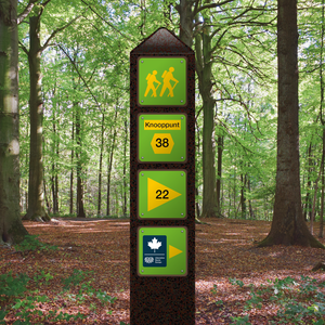
Liberation Route Brabant direction signs
Follow the 'Liberation Route' signs with the maple leaf. These are hanging under the regular junction signs.

-
Hotline routes
Hotline routesIf there is something wrong on the route, report it here.
Sights on this route
Starting point:
Waypoint walk 08
Sprang-Capelle
Navigate to starting point
Waypoint walk 08
Sprang-Capelle
Navigate to starting point
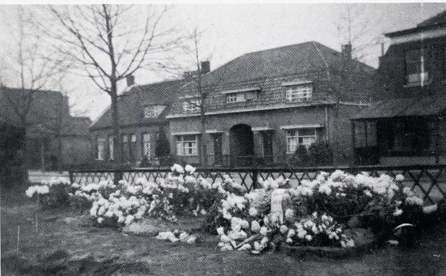
Initial, temporary resting place
After the liberation of North Brabant, the River (Bergse) Maas became the new front line. In November 1944, the 1st Battalion of the Canadian Algonquin Regiment, led by Lieutenant-Colonel R.A. Bradburn, was responsible for the sector north of Waalwijk.
Starting point:
Burgemeester van der Klokkenlaan 375141 EE Waalwijk

Initial, temporary resting place
Initial, temporary resting place
Burgemeester van der Klokkenlaan 37
5141 EE Waalwijk
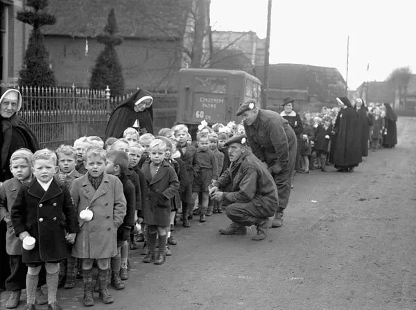
Early Christmas for Dutch children
On Tuesday 19 December 1944, in both Heusden and Elshout, Canadian servicemen organised a big party with a Father Christmas, a film screening, gifts and good food and drink. Although German shells also fell on the day of the event, the party still went ahead, much to the delight of local youth.
Starting point:
Kerkstraat 375154 AN Elshout

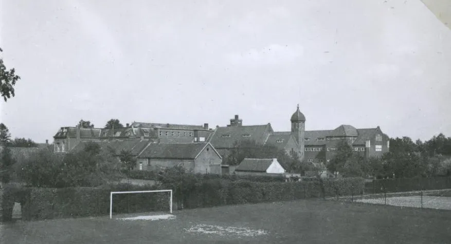
Canadian soldiers amongst Brabant nuns
Even during quiet periods at the front, military training continued. In late 1944, the Canadian troops found an ideal spot in Udenhout. The site was especially suitable due to its location near the Loonse and Drunense Dunes, which was traditionally a military training area.
Starting point:
Schoorstraat 25071 RA Udenhout

Canadian soldiers amongst Brabant nuns
Canadian soldiers amongst Brabant nuns
Schoorstraat 2
5071 RA Udenhout
End point:
Waypoint walk 35
Udenhout
Navigate to endpoint
Waypoint walk 35
Udenhout
Navigate to endpoint
Story of the route
Starting point:
Waypoint walk 08
Sprang-Capelle
Navigate to starting point
In the footsteps of the Canadian Liberators
In 1944-1945, the Canadian military played a major role in the liberation of the Netherlands. With this walking tour you follow in their footsteps, beginning in Zeeland and going right across the Netherlands to Groningen. En route you will hear familiar and obscure tales.
The Canadian effort began in the autumn of 1944 during the Battle of the Scheldt, one of the longest military operations during the war on Dutch soil. For weeks there was heavy fighting in the north of Belgium, Zeeland and West Brabant, fighting for control of both banks of the Western Scheldt.
On 5 October 1944, the first Canadians of the 2nd Infantry Division marched into Brabant from Belgium. The village of Putte was the first to be liberated. The ultimate goal was to secure the area around Hoogerheide-Woensdrecht, but that was not possible because the German defenders resisted so strongly. The battle to conquer both villages led to huge losses on both sides. Nowhere else in the Netherlands did the Canadians lose as many men as in these engagements.
After almost three weeks, the battle was over and a part of the Canadian forces could finally enter Zeeland. Another part continued the battle in a northerly direction, where the capture of Bergen op Zoom was a huge victory for the Canadians. At Nieuwe Veer, north of Prinsenbeek, the Polish 1st Armoured Division, also a part of the First Canadian Army, suffered a bloody defeat. After necessary rearguard actions with the retreating Germans, the liberators finally arrived at Dintelsas on 5 November.
Once the Poles captured Moerdijk on 9 November, the fighting in North Brabant subsided and the front came to a standstill. The Canadians spread out over a large part of the region. Various Canadian units occupied a long frontline from the island of Tholen up to Grave. The Canadians themselves called this period “Winter on the Maas”. The harsh winter of ‘44-‘45 brought with it difficult conditions with lots of ice and snow. Still, there were many opportunities to relax in the larger cities of North Brabant, such as spending any time off in the cinema in Den Bosch. Canadian units were also very interested in Sinterklaas and Christmas at gatherings organised especially for the children in North Brabant. It was this and billeting with citizens that allowed many residents in North Brabant to get to know the Canadians.
The German troops, however, were also a serious problem. Small groups of Germans regularly crossed the River Maas by boat. The bloodiest confrontation was a series of battles for the possession of the small island at Kapelsche Veer at the end of January 1945. The small German bridgehead at that location was only conquered by the efforts of many people and materials.
At the beginning of February 1945, most of the Canadians in North Brabant left to participate in a major offensive in Germany’s Rhineland. The Canadian army headquarters in Tilburg continued to be used for a long time. After crossing of the Rhine, the Canadians returned to the Netherlands to liberate the east and north of the country as well. They were supported by French parachutists who landed in Drenthe and by Polish and Belgian troops who were under Canadian command. With the exception of the West Frisian Islands, all of the northern provinces were fully liberated on 2 May 1945. That day was the day that the last Canadian was killed near the village of Geefsweer in Groningen during the bitter battle for the Delfzijl Pocket. Three days later, the German troops in the Netherlands surrendered.
A large Canadian military cemetery near Bergen op Zoom is a reminder to us of the many who died for freedom in North Brabant.
End point:
Waypoint walk 35
Udenhout
Navigate to endpoint
- 08
- 61
- 71
- 72
- 88
- 26
- 55
- 57
- 58
- 59
- 63
- 75
- 76
- 31
- 30
- 99
- 98
- 37
- 10
- 47
- 42
- 41
- 36
- 35
- 40
- 01
- 19
- 73
- 74
- 76
- 75
- 20
- 36
- 35
- 34
- 33
- 32
- 24
- 28
- 26
- 37
- 35

